
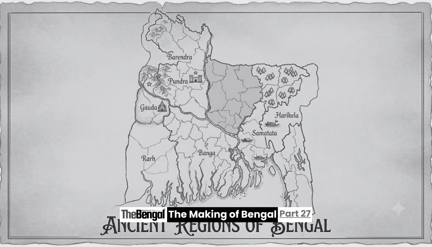

This article is part of The Making of Bengal, a long-form historical series by The Bengal. This chapter closes the Religion and Culture section, and with it the broader story of Ancient Bengal this series has followed since Gangaridai and Alexander’s retreat. Before we turn to Shashanka and the rise of Bengal’s first independent kingdom, it is worth pausing to ask a basic question this series has circled around from its very first chapter: when, and how, did all of this scattered territory actually become Bengal?
A Land of Many Names
Every chapter in this series has, in some sense, already answered this question in fragments. We have met Vanga, the seafaring, elephant-rich kingdom of the Mahabharata and the likely successor to Gangaridai. We have met Pundra, home to Pundranagara and the Mahasthan Brahmi inscription, Bengal’s oldest surviving written record. We have followed Samatata’s rise as a flourishing Buddhist kingdom in the trans-Meghna region, its influence reaching into Tripura and Assam. What none of these earlier chapters spelled out directly is just how many of these separate territorial identities existed simultaneously, and how genuinely fragmented ancient Bengal’s political geography actually was.
Historical surveys of the region typically identify six principal janapadas active across this period: Vanga, covering roughly the southern districts of the delta; Pundra, centred on Bogra and the surrounding area in the north; Radha, also known as Rarha, spanning much of what is now western West Bengal; Gauda, lying northwest of the Bhagirathi river with its core around Murshidabad; Samatata, in the Meghna river valley, stretching into Comilla, Noakhali and parts of Tripura; and Harikela, identified with Chittagong and its surrounding coastal territory. Some later sources expand this list considerably, with one detailed survey of the region’s ancient political geography counting as many as sixteen distinct janapadas active across Bengal’s early history, including Barendra alongside the more commonly cited six.
According to Banglapedia’s own account of this period, in the earliest phase Bengal was known to be inhabited by different groups of people, whose names came to be associated with the specific territories they inhabited. This is a crucial detail. These were not administrative divisions imposed from outside. They were, originally, distinct ethnic and cultural identities, non-Aryan peoples, as later Vedic literature described them, each occupying and defining a particular stretch of the delta on its own terms.
An Outsider’s Confirmation
That this fragmented political landscape was genuinely recognised, not merely a modern historian’s retrospective classification, is confirmed by outside observers writing at the time. The sixth-century Indian astronomer and polymath Varahamihira, in his Brihat Samhita, specifically listed six distinct territories corresponding to this same region: Gaudaka, Paundra, Vanga, Samatata, Vardhamana and Tamralipta, the port city already explored at length elsewhere in this series. Centuries earlier still, the Sanskrit scholar Vatsyayana, author of the Kamasutra and active around the third or fourth century CE, was already familiar with Gauda as a recognised regional identity, connected in his own writing to Vanga and Pundra as neighbouring eastern territories.
This matters because it demonstrates that Bengal’s fragmented political geography was not simply chaos, illegible even to contemporaries. It was a well-understood, named and mapped patchwork, familiar enough to a Sanskrit sexologist writing in the Gupta era and an astronomer writing two centuries later that both could casually reference its component parts without further explanation, the way a modern writer might casually mention England, Scotland and Wales without needing to define each one.
Borders That Never Held Still
What these janapadas were not, crucially, was stable. Historical surveys of the period describe their borders as constantly fluctuating, sometimes expanding, sometimes shrinking, and periodically warring with one another over land and resources. Gauda’s own political fortunes offer a clear illustration. The earliest solid evidence of Gauda’s territorial presence comes from an inscription commemorating the Maukhari king Ishanavarman, dated to 554 CE, which records his claim to have defeated the Gaudas living close to the sea. Centuries later, the same territory appears again in an entirely different context, when the Kashmiri historian Kalhana recorded that five separate Gauda kings were defeated by the northern Indian ruler Lalitaditya, a detail Banglapedia reads as clear evidence of political disintegration within Gauda, a region that had, by this point, fractured into multiple competing local chieftaincies operating without any unifying central authority.
This pattern repeated itself across the delta. Southeastern Bengal formed its own independent kingdom of Vanga as early as the first half of the sixth century CE, its rulers, including Gopachandra, Dharmaditya and Samacharadeva, known to us through six surviving copperplate inscriptions. When the so-called Later Guptas eventually captured power in Gauda during the latter half of the seventh century, southeastern Bengal responded with its own separate political development, the emergence of the Khadga dynasty, already discussed in the previous section of this series for its patronage of Buddhism in Samatata, ruling from a capital identified with modern Badkamta near Comilla.
Ancient Bengal, in other words, spent centuries as a landscape of parallel, competing, rising and falling local powers, never merging into one durable state on its own.
The Threads That Were Already Weaving Them Together
And yet, reading back across everything this series has already covered, it becomes clear that a shared identity was quietly forming beneath this political fragmentation, long before any single ruler managed to unify it politically. The rivers that built the delta, examined in this series’ earliest chapters, ran through every one of these janapadas alike, ignoring their borders entirely. The rice cultivation explored in an earlier chapter created a broadly shared agricultural economy and, as that chapter documented in detail, an entire vocabulary and ritual calendar built around a single crop, stretching across Vanga, Pundra, Radha and beyond without regard for political division. The Prakrit-derived language explored two chapters ago was evolving along a broadly shared trajectory across this same territory, eventually giving rise to Bangla, Assamese and Oriya together from the same eastern Magadhi root. And the religious transformations covered in the two preceding chapters, Buddhism’s spread through Tamralipti, Pundravardhana and Samatata alike, and the rise of Puranic Hinduism reaching Damodarpur and beyond, moved across janapada boundaries as though they barely existed.
Politically fractured, in other words, did not mean culturally disconnected. By the sixth century, the various peoples of Vanga, Pundra, Radha, Gauda, Samatata and Harikela shared rivers, shared crops, shared an evolving language, and increasingly shared religious frameworks, even while remaining, for the most part, stubbornly separate as political entities, each with its own rulers, its own rivalries, and its own claims to independence.
Waiting for a Single Name
What ancient Bengal lacked, as this chapter closes and this series turns toward its next section, was not a shared culture but a shared political roof. The pieces, geographic, linguistic, religious, economic, were already substantially in place. What remained was for someone to actually claim political authority over enough of this fractured territory at once to make the idea of a unified Bengal something more than a geographical convenience used by outside astronomers and grammarians.
That is precisely where this series turns next. In the early seventh century, a ruler named Shashanka, based in Gauda, did exactly that, becoming, in the eyes of many historians, the first king to rule over a genuinely unified and independent Bengal. The janapadas explored in this chapter did not disappear when he did so. Vanga, Pundra, Radha, Samatata and Harikela would all continue to exist as regional identities for centuries afterward, some of their names surviving in local memory even today. But from Shashanka’s reign onward, they would increasingly be understood not simply as separate, rival territories, but as component parts of something larger: Bengal itself.
In the next chapter of this series, we begin a new section, tracing the end of empire and the rise of Bengal’s first independent kingdom under the man many historians still consider its founding king.
Sources: Banglapedia, “History”; National Culture and Heritage, “Ancient Bengal”; Studocu, “HIS 101 Lecture Notes: Ancient Bengal Political and Religious History,” “HIS101: Exploring the Ancient Janapadas of Bengal History” and “EMB(2) Ancient Bengal: Hindu-Buddhist Dynasties and Their Legacy”; Scribd, “History of Bangladesh: Ancient Period” and “Janapadas of Ancient Bengal Explained.”