

This article is part of The Making of Bengal, a long-form historical series by The Bengal. Earlier chapters in this section traced Bengal’s maritime reach across the Bay of Bengal, from its ports at Tamralipta and Gange to the legendary voyage of Prince Vijaya toward Sri Lanka. This chapter widens the map considerably, showing that Bengal’s trading reach was never confined to the sea at all. Overland, too, the delta sat at the meeting point of routes running toward China, Tibet and Central Asia.
A Chinese King’s Puzzling Discovery
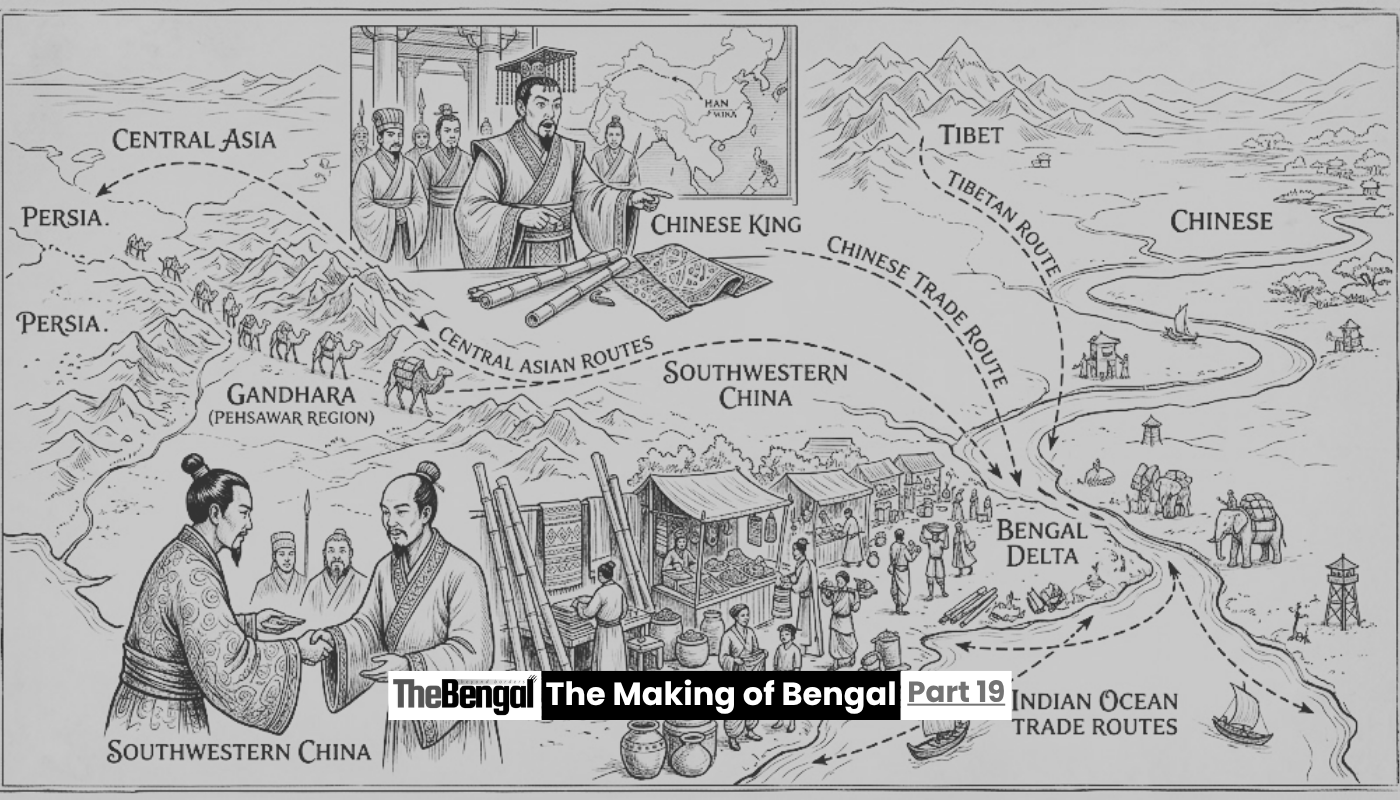
The clearest early evidence for this overland network comes from an unexpected source: a moment of confusion in a market thousands of kilometres from Bengal itself. Around 127 BCE, a Chinese ruler identified in later accounts as King Chiang Kein came across bamboo products and textiles from southwestern China being sold in the markets of Gandhara, in what is now northern Pakistan. Puzzled by how goods from so deep inside China had ended up there, he made inquiries and learned that these products had travelled through eastern India, meaning Bengal, having first passed through Yunnan and Burma, before being carried onward across northern India to Bactria in Central Asia.
This anecdote is echoed in the Shiji, the first Chinese dynastic history, compiled between 104 and 87 BCE, which records that the Han-dynasty envoy Zhang Qian, exploring Central Asia around 122 BCE, similarly reported that goods from Sichuan and neighbouring southwestern regions of the Chinese empire were reaching Bactria by passing through India. Emperor Wu of the Han dynasty, intrigued by this discovery, apparently tried to establish a direct, formal trade route between China and India via Yunnan, only to be blocked by local rulers in Yunnan itself, who had no interest in ceding control over a route their own territory sat astride. The formal diplomatic effort failed. The trade itself, evidently, did not need official sanction to keep functioning.
The Long Road Through Yunnan and Assam
What these Chinese sources were describing has since come to be known as the Southern Silk Road, sometimes called the Southwestern Silk Road, a roughly two-thousand-kilometre overland network linking Sichuan and Yunnan in southwestern China with eastern and northeastern India, running through Myanmar and into Assam before reaching Bengal itself. Archaeological evidence recovered along the southern banks of the Brahmaputra, extending up to the Myanmar border, confirms that genuine trade moved along this corridor, carrying Chinese silk, Sichuan cloth, bamboo walking sticks and ironware westward, while glass beads, jewels and emeralds moved back east in exchange.
This was never an easy route. The terrain crossing from Yunnan through Upper Burma into Assam is mountainous and difficult, and researchers note that the peoples inhabiting these border regions were often politically fragmented, making the safety of merchants travelling the route a persistent concern throughout its long history. Even so, the route persisted for well over a thousand years, resurfacing repeatedly in later historical periods. Detailed studies of the medieval bullion trade have traced three distinct overland paths carrying gold and silver from Yunnan and Upper Burma into Bengal between roughly 1200 and 1500 CE, each threading through slightly different mountain passes and river valleys before converging on the Brahmaputra valley and, from there, into Bengal proper. The route’s strategic value did not fade even in the modern era. British colonial administrators sought to control sections of it from 1885 onward, and during the Second World War, the Allies built the Stilwell Road, also called the Ledo Road, from Ledo in Assam to Kunming in Yunnan, tracing much the same ancient path to supply Chinese forces fighting Japan, before the jungle reclaimed most of the route once the war ended.
A Second Path, Descending From Tibet
Bengal’s overland connections were not limited to the route through Assam and Burma. A separate corridor, sometimes called the Southwest Silk Route or the Sikkim Silk Route, connected Yunnan and India by way of Tibet, running from Lhasa across the Chumbi Valley and through the Nathu La Pass, a high mountain crossing still used today, down toward the port of Tamralipta, already discussed at length in earlier chapters of this series for its role in Bengal’s maritime trade with Sri Lanka and Ashoka’s Buddhist missions.
This is a genuinely striking piece of ancient geography. It means Tamralipta functioned simultaneously as a maritime harbour, launching ships toward Sri Lanka, Bali and Java, and as the southern terminus of an overland route reaching all the way back to the Tibetan plateau. Goods and travellers descending from Lhasa could, in principle, walk down through the Himalayan passes, reach Bengal’s coast, and step directly onto a ship bound for the wider Indian Ocean world, all without the route ever needing a name grand enough to be remembered as its own Silk Road in Western historical memory.
Later Chinese and classical sources confirm that this general pattern, overland routes from eastern India reaching toward China via two main paths, one through Assam and Burma, the other through Sikkim and Tibet, was well understood by contemporaries, even if the exact routes shifted somewhat over the centuries. From the Bengal end, three distinct paths are recorded linking Assam to Bengal proper: one following the Brahmaputra River itself as a natural waterway, and two overland routes running along the northern and southern banks of the river respectively, with the southern path favoured by merchants whose ultimate interest lay in reaching Bengal’s own sea ports.
Cowrie Shells and the Reach of a River Delta
Perhaps the most remarkable evidence for just how far this network extended comes from an unlikely source: small, unremarkable seashells. Archaeologists in Yunnan have recovered tens of thousands of cowrie shells from tombs dating between the Warring States period and the early Han dynasty, shells whose ultimate origin traces back to the Pacific and Indian Oceans, particularly the Maldives. For years, the exact path these shells took to reach landlocked southwestern China remained unclear. Researchers studying the question have concluded that the more probable route ran first by sea from the Maldives to Bengal, and only then overland through Assam and Burma into Yunnan, rather than a more difficult and less plausible direct sea route between the Maldives and Burma.
If that reconstruction holds, it means cowrie shells gathered from Indian Ocean atolls thousands of kilometres to the south were being funnelled through Bengal’s ports specifically because the delta offered the most efficient link between maritime and overland Asian trade, exactly the kind of role a genuine crossroads is supposed to play. This use of cowries as currency in both Yunnan and the wider Bay of Bengal region persisted for centuries, from roughly the ninth to the mid-seventeenth century, according to some estimates, a remarkably durable monetary link running straight through Bengal’s markets.
Bengal’s Cities, Standing on the Route
None of this overland traffic bypassed the cities already explored elsewhere in this series. Later scholarship examining the emerging archaeological record from Bangladesh has proposed that a route running from Sichuan through Yunnan and Burma into Bengal explains why so many of the region’s ancient cities cluster where they do. Wari-Bateshwar, Mahasthangarh, and other sites such as Bhitagarh, Bikrampur, Egarasindhur and Sonargaon are increasingly understood not as isolated urban curiosities but as international trade centres positioned directly along this Sichuan-Yunnan-Burma-Bangladesh corridor, feeding goods onward into the maritime networks discussed in earlier chapters of this series.
That dual identity, cities that were simultaneously river ports, overland trade termini and gateways to the open sea, is precisely what made Bengal so difficult for any single ancient power to ignore, whether Mauryan administrators managing famine relief at Pundranagara, Greek geographers trying to map Gangaridai’s coastline, or Chinese emperors puzzling over how their own silk had ended up so far from home.
A Crossroads by Geography, Not by Design
What emerges from all of this is a picture of Bengal that goes well beyond its own borders. This was never simply a fertile delta producing rice and cotton for its own use, nor merely a maritime trading power looking out toward the Bay of Bengal. It was a genuine hinge point, connecting the overland world of Central Asia, Tibet and southwestern China to the maritime world of Sri Lanka, Southeast Asia and the wider Indian Ocean, with Assam’s river valleys and mountain passes forming the essential connective tissue between the two.
No single ruler planned this arrangement. It emerged from geography itself, from the accident of where mountains, rivers and coastlines happened to meet, and from the accumulated decisions of countless merchants, monks and travellers who simply found, over many centuries, that Bengal was where their routes converged whether they intended it or not.
In the next chapter of this series, we look more closely at the specific goods, silk, spices and river cargo, that actually moved along these converging routes, and what they tell us about the wealth this crossroads position brought to ancient Bengal.
Sources: The Peninsula Foundation, “India-China Trade in Ancient Times: Southern Silk Route”; Grokipedia, “BCIM Economic Corridor”; Wikipedia, “Silk Road”; South China Morning Post, “‘Southern Silk Road’ Linking China and India Seen as Key to Boosting Ties”; UNESCO World Heritage Centre, “Silk Road Sites in India”; UNESCO Silk Roads Programme, “Did You Know?: The Southern Silk Roads”; Bin Yang, “Between Winds and Clouds,” Gutenberg-e; Facts and Details, “Silk Road in India.”