
This article is part of The Making of Bengal, a long-form historical series by The Bengal tracing how one of South Asia’s most distinctive civilizations took shape across thousands of years. Our first installment introduced the earliest people to settle this land. Before we return to them, it is worth pausing on a question that rarely gets asked: what was here before there was anyone to ask it? Long before Bengal had a name, the land itself had to be made.
A Continent That Broke Apart
To understand Bengal, you first have to travel back roughly 140 million years, to a time when the map of the world looked nothing like it does today. India, as a landmass, did not yet exist in any recognisable form. It was still bound to a vast southern supercontinent known as Gondwana, sitting far south of the equator, fused together with what would eventually become Africa, Antarctica, Australia and South America.
Then Gondwana began to break. Piece by piece, the supercontinent fractured, and the fragment that would become the Indian subcontinent broke free, setting off on one of the strangest journeys in geological history. Freed from its neighbours, this drifting landmass began moving north, crossing open ocean at a pace that geologists consider remarkably fast, inching toward a collision that would take tens of millions of years to complete but would ultimately reshape the entire region.
There was no Bengal yet. There was, in fact, no Himalayas, no Ganges, no Brahmaputra. Just an isolated island continent drifting alone across a primordial sea.
The Collision That Built a Mountain Range
Roughly fifty million years ago, give or take a few million, that long journey ended. The northern edge of the drifting Indian plate finally slammed into the southern margin of Asia. It was not a single dramatic impact but a slow, grinding collision that continues, quite literally, to this day. India is still pushing northward into Asia at a rate of a few centimetres a year, and the ground beneath the Himalayas is still rising because of it.
That collision is what built the Himalayas, and the Himalayas are what eventually built Bengal.
As the Indian plate pushed beneath and against the Eurasian and Burmese plates, enormous quantities of rock were folded, crushed and forced upward into the sky, forming the highest mountain range on the planet. But mountains, however permanent they may look, are never static. From the moment they began to rise, they also began to erode, and that erosion is the second half of the story.
Rivers Born to Carry a Mountain to the Sea
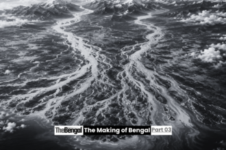
Rain, snowmelt and gravity immediately set to work on the newly rising Himalayas, grinding rock into sediment and washing it downhill. Two rivers in particular, the Ganges and the Brahmaputra, took on the job of carrying that material away from the mountains and out toward the sea.
Together with a third river, the Meghna, these waterways have spent tens of millions of years hauling an almost unimaginable volume of eroded rock, sand, silt and clay down from the highlands and depositing it across a low-lying basin to the south. The scale of this transport is difficult to overstate. Even in the present day, the Ganges-Brahmaputra-Meghna river system carries more than one billion tonnes of sediment into the Bay of Bengal every single year, water and debris gathered from a watershed spanning parts of five countries: India, Nepal, Bhutan, China and Bangladesh.
Over millions of years, that endless deposit of sediment did something extraordinary. It built land. Layer upon layer, flood after flood, the rivers filled a subsiding basin with material scraped from the Himalayas, gradually constructing what would become the largest river delta on Earth, the Ganges-Brahmaputra delta, the physical foundation of Bengal itself. In places, geologists have measured more than twenty kilometres of accumulated sediment beneath the delta, a staggering record of just how much of the Himalayas has quite literally been washed downstream and reassembled as flat, fertile land.
A Delta Still Under Construction
What makes this story unusual is that it never really finished. Unlike a mountain range that eventually stabilises, or a coastline that settles into a fixed shape, the Bengal delta has always been a work in progress, and in many ways still is.
The rivers did not simply deposit sediment in one place and stop. Over geological time, the Ganges shifted its course repeatedly, building and then abandoning multiple earlier deltas before settling into something closer to its present position. The Brahmaputra behaved similarly, once flowing on a course much further east near present-day Mymensingh before eventually straightening into a more southward path. As the Indian plate continued its slow collision with Asia, the Shillong Plateau rose, the Indo-Burman ranges folded upward, and these tectonic movements repeatedly nudged the great rivers into new channels, reshaping the emerging landscape again and again.
Sea level added yet another layer of complexity. During ice ages, when vast quantities of the world’s water were locked into glaciers, sea levels dropped by well over a hundred metres, exposing land far south of today’s coastline and allowing rivers to carve deep canyons into what is now the floor of the Bay of Bengal. When the ice melted and seas rose again, the delta plain was flooded and reshaped once more. The land that would one day be called Bengal was never a finished product. It was, and remains, a landscape in permanent negotiation with its rivers and its sea.
The Bones Beneath the Delta
Underneath the flat green plains that later generations would till, plant and build upon, geologists have identified a much older and more rigid skeleton. To the north and west, the delta rests against ancient crystalline rock, remnants of ancient continental crust that long predate the delta itself. To the east, it meets younger, folded mountain belts formed by the ongoing collision with the Burmese plate. Elevated terraces of far older sediment, features like the Barind and Madhupur tracts, stand as slightly raised islands amid the surrounding floodplain, geological leftovers from earlier phases of the delta’s long construction.
This underlying structure explains a great deal about the land’s later human history. The slightly higher, drier terraces offered rare islands of stability in an otherwise flood-prone landscape, and it is no coincidence that some of the earliest human settlements in the region, including the early urban centre explored in an earlier piece in this series, tended to cluster on exactly this kind of flood-free high ground. The choices made by the very first farmers and city-builders of Bengal were, in a very real sense, shaped by tectonic decisions made tens of millions of years earlier.
A Land Without a Name
For most of this immense span of time, geological time, there was no one present to give the land a name. There was no Bengal, no Bangla, no word for the rivers, the silt or the slowly emerging coastline. There was only rock, water and time, operating according to forces that had nothing to do with human history and everything to do with plate tectonics, erosion and sediment.
And yet, in a quiet and indirect way, this is where Bengal’s story truly begins. The astonishing fertility of the delta’s soil, the very quality that would later support some of the densest agricultural populations on Earth, exists only because of this deep, patient process of mountain-building and river-borne deposition. The maze of channels that would one day carry trade goods, silk, spices and beads, as we saw in the story of Wari-Bateshwar, were carved by the same rivers that had spent millions of years constructing the land in the first place. Even the restless, ever-shifting nature of Bengal’s geography, so often described by later chroniclers and colonial administrators as unpredictable and unstable, is simply the continuation of a habit the land developed long before anyone was around to complain about it.
By the time the first humans arrived on these floodplains, the land was not a blank stage waiting for history to begin. It was already an old and complicated place, built from the bones of a broken supercontinent and the sediment of a mountain range still being born. It had no name yet. But it was, in every physical sense, already Bengal.
In the next chapter of this series, we return to the human story, tracing how the descendants of early settlers, standing atop this ancient and still-shifting delta, went on to build the fortified towns, kingdoms and civilizations that would finally give the land the name and identity we recognise today.
Sources: Banglapedia entry on the Bengal Delta; The Geological Society of London; ScienceDirect research on the Bengal Depositional System and the Ganges-Brahmaputra western delta plain; BioOne Journal of Coastal Research studies on the evolution of the Bengal Delta; The Daily Star’s reporting on the geological history and future of the Bengal Delta.